
GPR Technical Guide
Ground Penetrating Radar FAQ
Clear answers to common questions about how GPR works, what it can detect, how frequency affects performance and what must be considered before selecting a system.
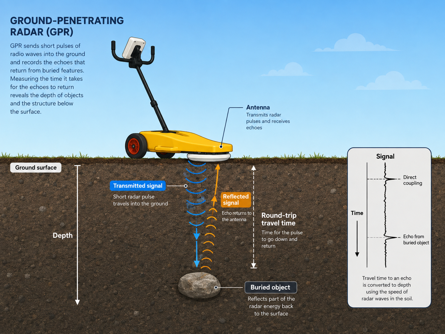
The Basic Principle
GPR records reflections from changes beneath the surface
The system transmits electromagnetic energy into the surveyed material and records energy reflected by boundaries, objects and changes in material properties.
Transmit
A transmitting antenna emits a controlled radar pulse into the ground, concrete, road structure or other investigated material.
Reflect
Part of the energy is reflected when it encounters a sufficiently strong change in electrical properties, material or geometry.
Receive
The receiving antenna records the returning signal and its travel time. Repeated measurements create a continuous survey record.
Interpret
The resulting data is reviewed to identify targets, layers, interfaces and anomalous areas relevant to the investigation.
Resolution and Depth
There is no single frequency for every investigation
Higher frequencies generally provide finer target definition but usually penetrate less deeply. Lower frequencies generally investigate deeper but provide less detail on small or closely spaced targets.
Higher frequency
Commonly selected for shallow layers, small targets, concrete and applications requiring detailed near-surface information.
Mid-range frequency
Often used where a practical balance between useful depth and target definition is required.
Lower frequency
Used for deeper investigation and larger targets where near-surface fine detail is less important.
Multiple frequencies
Combining frequency ranges can provide a broader subsurface picture than relying on one antenna alone.
Category 01
GPR basics
Start with what GPR measures, what produces a response and how it differs from other locating technologies.
What is Ground Penetrating Radar?
Ground Penetrating Radar, usually abbreviated to GPR, is a non-destructive investigation method that uses electromagnetic energy to examine materials below an accessible surface.
It is used in applications including utility investigation, roads, railways, concrete, archaeology, environmental surveys and specialist research.
How does GPR work?
A transmitting antenna sends radar energy into the investigated material. Changes in electrical properties, material boundaries and buried objects can reflect part of that energy back to a receiving antenna.
The system records the strength and travel time of the returned signals as the equipment moves across the survey area.
What can GPR detect?
GPR can respond to a wide range of targets and changes, including:
- Metallic and non-metallic pipes
- Cables, ducts and drainage
- Concrete reinforcement and construction features
- Voids, disturbed ground and washouts
- Changes between road, soil or structural layers
- Archaeological features and buried objects
Detectability depends on target size, depth, orientation, frequency, site materials and the contrast between the target and its surroundings.
Does a target have to be metallic?
No. GPR does not rely on a target carrying an electrical current or being made from metal. It responds to differences in electrical properties and geometry.
Plastic pipes, concrete ducts, earthenware drainage, voids and other non-conductive features can therefore produce a radar response where conditions permit.
Is GPR the same as an electromagnetic cable locator?
No. Electromagnetic locating and GPR operate on different principles and provide different information.
Electromagnetic locating is highly valuable for tracing suitable conductive services. GPR can add information about conductive and non-conductive targets, disturbed ground and other subsurface changes. The two methods are commonly used together.
Is GPR destructive?
GPR itself is non-destructive because it collects information from the accessible surface without drilling, coring or excavation.
Physical verification may still be required where a survey result affects safety, engineering or construction decisions.
Category 02
Depth, frequency and accuracy
Survey performance depends on the interaction between wavelength, target size, recording time and site conditions.
How deep can GPR investigate?
There is no universal GPR depth. Useful investigation depth depends on antenna frequency, target size, ground conductivity, moisture and the required level of definition.
Lower frequencies may penetrate more deeply, while higher frequencies generally provide better definition over a shallower range. Product depth figures should therefore be treated as indicative rather than guaranteed for every site.
How do I choose the correct antenna frequency?
Frequency should be selected around the expected target size, depth, separation and required detail.
- Use higher frequencies for smaller and shallower targets
- Use lower frequencies for deeper and larger targets
- Consider multiple frequencies where the target range is varied
- Consider surface access and site conductivity
Why might one frequency miss a target?
The target may be too small relative to the wavelength, too deep for the selected frequency, poorly oriented to the survey line or masked by surrounding materials.
Two closely spaced targets may also appear as one response where the system cannot resolve the separation between them.
Why use more than one frequency?
Different frequencies emphasise different parts of the subsurface. A mid-range antenna may provide general depth coverage, while a higher-frequency antenna may improve the definition of small, shallow or closely spaced targets.
Multi-frequency collection can reduce the risk of basing an investigation on one limited view.
How is target depth calculated?
GPR records signal travel time, usually in nanoseconds. Converting that time into a physical depth requires an estimate or measurement of the radar-wave velocity through the investigated material.
Velocity varies between materials and can change with moisture and site conditions. Calibration is therefore important where accurate depth information is required.
How accurate is GPR?
Accuracy depends on what is being measured. Position accuracy depends on the survey positioning method. Depth accuracy depends on transmission-velocity calibration. Target definition depends on wavelength, survey density and data quality.
A precise time measurement does not automatically produce a precise depth unless the velocity conversion is also reliable.
Can collection settings be corrected after the survey?
Some display and processing parameters can be adjusted later when raw data has been retained. However, information that was never recorded cannot be reconstructed.
For example, when the selected time window is too short for the required depth, the missing deeper data cannot be recovered after collection.
Category 03
Ground and site conditions
Ground conditions can influence penetration, signal strength, velocity and the visibility of individual targets.
Does GPR work in every type of ground?
No investigation method performs equally well in every environment. GPR generally performs best where sufficient radar energy can enter the material and return to the receiver.
Highly conductive conditions can strongly absorb radar energy and reduce useful penetration.
Why can wet clay cause problems?
Some wet clays contain conditions that significantly attenuate radar energy. Less energy returns to the receiver, reducing the amount of useful subsurface information.
Not all clay behaves identically, so the effect must be considered in relation to the particular site.
Does salt water affect GPR?
Yes. Salt water is highly conductive and can absorb radar energy very strongly. Surveys involving saline materials or salt-water saturation may therefore have severely restricted penetration.
Can rainfall change the results?
Yes. Increased moisture can change radar-wave velocity and attenuation. A site surveyed after heavy rainfall may therefore behave differently from the same site in dry conditions.
Moisture changes may affect both achievable depth and the conversion from travel time to physical depth.
Can GPR be used on reinforced concrete?
Yes, but frequency and target spacing are important. Higher frequencies are commonly used for detailed concrete investigation.
Closely spaced reinforcement can restrict the ability to image features beneath it, particularly where the radar wavelength is too long relative to the gaps between the bars.
Can antennas be used over rough ground?
Surveys can be adapted using trolleys, protected skids, hand-towed arrangements, vehicle mounting or specialist frames. The correct method depends on access, surface roughness, required coupling and survey speed.
Poor contact or excessive variation between the antenna and surface may reduce consistency and data quality.
Why did a GPR survey appear not to work?
A weak or unclear survey result should be investigated rather than simply described as a failed site. Possible causes include:
- Conductive or saturated material
- Unsuitable antenna frequency
- Insufficient recording depth
- Targets too small for the wavelength
- Inappropriate survey orientation or spacing
- Poor coupling or unsuitable deployment
- Incorrect assumptions during interpretation
Category 04
Survey collection and interpretation
The value of a GPR survey depends on suitable collection, positioning, interpretation and verification.
What does a conventional GPR display show?
Conventional GPR commonly displays a radar profile or radargram. This shows how reflected signal strength changes with travel time as the antenna moves along the survey line.
Objects, layers and interfaces can produce different patterns. Interpretation involves distinguishing meaningful responses from clutter, noise and unrelated site features.
Does every GPR require radargram interpretation?
Most professional GPR systems provide radar data that requires competent interpretation. These systems are appropriate where the user needs detailed information, survey records or analytical control.
e-Safe is different. It is designed for utility avoidance and processes the radar response into a more straightforward indication rather than requiring conventional radargram interpretation.
How is the survey position recorded?
Position can be recorded using a distance encoder, survey reference lines, GPS or total-station information, depending on the required accuracy and survey environment.
Detailed utility mapping and infrastructure investigation normally require more precise positioning than a localised pre-excavation check.
Should a site be surveyed in more than one direction?
Often, yes. Linear targets are usually most clearly identified when the survey line crosses them rather than running parallel to them.
Surveying in suitable orientations and using an appropriate grid can improve the likelihood of detecting targets whose routes are not already known.
Can GPR identify what an object is made from?
Not reliably from a radar response alone. GPR identifies reflections and patterns caused by contrasts within the investigated material.
Target identity is inferred from factors such as position, shape, continuity, depth, site records and the wider survey evidence. Physical verification may be required.
Can GPR data be collected from a vehicle?
Yes. Suitable GPR configurations can be mounted on vehicles or trailers for roads, large-area surveys and other applications where efficient collection is required.
Survey speed must remain compatible with the scan rate, positioning system, required data density and surface conditions.
What is the difference between single-channel and multi-channel GPR?
A single-channel system collects from one antenna channel at a time. Different antennas can be used in separate survey passes.
A multi-channel system can collect from several antennas or frequency arrangements during the same survey pass. This can increase coverage, provide multiple frequency views or create denser survey information.
Does a GPR survey provide excavation clearance?
No. GPR results are one source of subsurface information. The absence of a radar response does not prove that the ground is clear.
Utility-avoidance work should include appropriate plans, electromagnetic locating, competent assessment, safe-dig procedures and suitable physical verification.
Different GPR Workflows
Utility avoidance and professional investigation are not the same task
Start with the decision the user must make and the level of information required from the survey.
Pre-excavation information
Focused on identifying potential subsurface hazards within a defined work area before excavation or ground penetration.
- Straightforward site workflow
- Localised investigation
- Processed target indication
- Used alongside established locating methods
- Commonly associated with e-Safe
Detailed survey information
Focused on collecting, interpreting and positioning radar data for mapping, engineering and specialist investigation.
- Professional radar interpretation
- Configurable frequency selection
- Single- or multi-channel collection
- Survey positioning and records
- Commonly associated with GroundVue
Category 05
Selecting a GPR system
Define the investigation before choosing the equipment, configuration or antenna frequency.
What information is needed before selecting a GPR?
Useful starting information includes:
- The application and required deliverable
- Expected target material and size
- Expected depth range
- Survey area and required collection speed
- Ground or structural material
- Surface access and deployment limitations
- Required positioning accuracy
- The operator’s interpretation experience
Should I select the product or application first?
Start with the application. The target, site conditions, required depth, required detail and intended output should determine the equipment.
Selecting a product first and then trying to make it fit every application can lead to unsuitable frequency, insufficient data density or unnecessary complexity.
Do I need a single-channel or multi-channel system?
Single-channel systems can be appropriate for targeted work, smaller areas and surveys where antennas can be changed between passes.
Multi-channel systems are valuable where simultaneous frequency collection, wider coverage, dense survey spacing or higher productivity is required.
Do all operators require the same level of GPR knowledge?
No. Detailed professional investigation requires knowledge of survey design, antenna selection, data quality, calibration and interpretation.
Utility-avoidance tools such as e-Safe are designed around a more straightforward operating workflow, but users must still understand the product’s purpose, limitations and role within the wider safe-dig process.
Which UTSI product should I choose?
The appropriate product depends on the investigation rather than one specification alone.
Review the UTSI product range or contact UTSI with details of the target, expected depth, site conditions, survey area and required output.
Important Limitation
GPR provides information, not certainty
A radar response does not automatically identify a target, and the absence of a response does not prove that no target is present. Results depend on the equipment, survey method, site conditions, target characteristics and interpretation.
Where safety, excavation or engineering decisions depend on the result, GPR should be used within an appropriate investigation process that includes other available evidence and suitable verification.
Further Technical Guidance
Start with the application, target and required survey outcome
Tell us what must be investigated, the expected depth, site conditions and the information required from the survey.